- Home
- Learn about salinity
- Get to know your site
- Design a landscape
- Solve a problem
- Other information
Salinity Management Guide
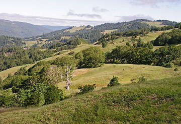
Assessing a site's topography
Variations in the elevation and steepness of the land surface give rise to the hills, ravines, and valleys that provide the underlying form of a landscape.
Such variations — the topography of a site — can greatly affect the movement of water though soil. This is partly a result of gravity, which directly influences water movement, and partly a result of topography's influence on soil development: soils typically are thinner at higher elevations and on steep slopes, and thicker in valleys or on level ground.
Topography also influences the microclimates that exist within a landscape — that is, the variations in exposure to sun and wind.
In short, topography can affect nearly everything related to the presence or movement of water in soil. It is a major factor in determining how much water enters the soil, how much water is stored in the soil, how the water moves through the soil, and how much water is lost from the soil as a result of evaporation or other processes.
It's easy to see, then, that topography of a site can also affect the amount of salts that remain in the soil after irrigation and which may accumulate over the course of time. In light of this, it's wise to monitor the salinity of soils in both the high and low spots in your landscape. Such monitoring can be accomplished by visually inspecting those spots at regular intervals throughout the year, especially during the rainy season. The monitoring program can be made even more effective by collecting samples of soil from those high and low spots and arranging to have the soil tested by a commercial laboratory to evaluate certain salinity-related chemical parameters.
| « Previous page | Next page » |